Indonesian seas Numerical Assessment of the Coastal Environment (IndoNACE)
Contents
Description of the IndoNACE Project:
This Pilot Study will aim at improving the information on the state of the marine environment that is gained from satellite data. Synthetic aperture radar (SAR) data will be used to produce oil pollution density maps of dedicated areas in Indonesian waters. In parallel, maps of particularly vulnerable coastal areas will be produced, which will be based upon http://geodata.grid.unep.ch/ complimented by environmental data hosted by the Indonesian partner institute. A numerical model will be used to combine both information sets, on existing pollution and on sensitive coastal areas. We will demonstrate that our approach can be used to identify strongly affected coastal areas (with most oil pollution being driven onshore), but also sensitive parts of major ship traffic lanes (where any oil pollution is likely to be driven into marine protected areas.
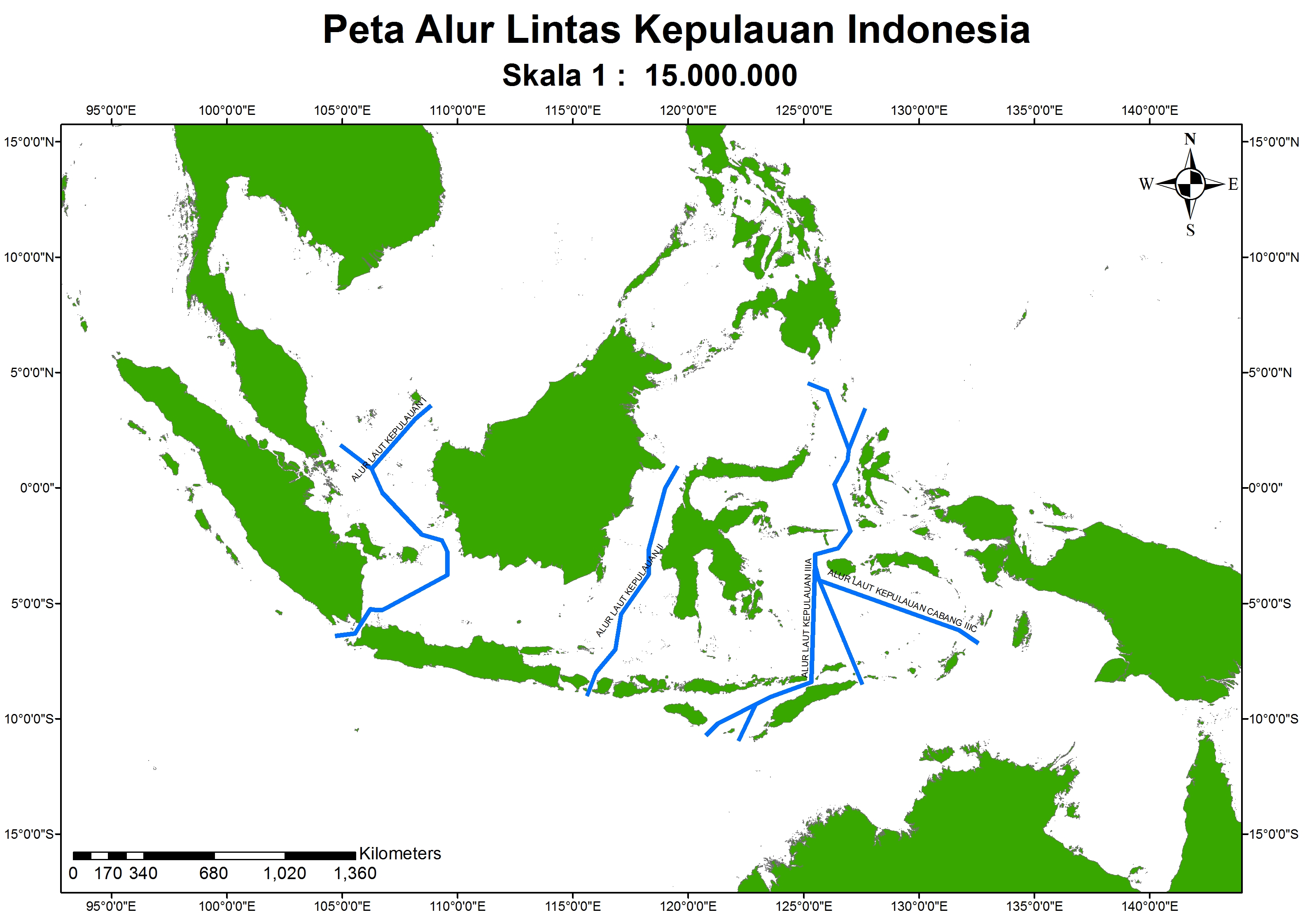
Indonesian territorial waters cover about three million square kilometres, thereby being larger than the Mediterranean Sea, and are home to more than 3.000 species of fish and more than 500 species of corals. The Indonesian coastline is longer than 80.000 kilometres, and the Indonesian archipelago encompasses more than 17.000 islands. Major ship traffic routes, connecting the economic centres on the South China Sea (and beyond) with Europe, Africa, Australia, or the Persian Gulf, run through Indonesian waters (Fig. 1).

Fig. 1. Main ship traffic routes through Indonesian territorial waters.
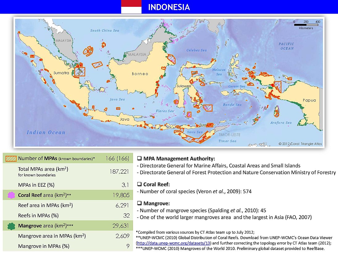
Albeit its total oil production has decreased by 25% during the past decade, Indonesia still ranks amongst the top 25 oil producing countries worldwide and is the third-largest oil producer in Pacific Asia (BP, 2014). However, not only because of a continuously increasing demand Indonesia, along with its neighbouring countries, has always been importing oil from other countries worldwide. The marine ecosystem in Indonesia is under increasing pressure due to social and economic growth in the entire region. Parts of the so-called Coral Triangle, a six million square kilometres area in Pacific Asia, lie in Indonesian territorial waters, where the coral reef area is estimated to be 20,000 square kilometres in size (Fig. 2). Along with mangrove forests and seagrass meadows on the coasts, these areas are particularly vulnerable to pollutants.

Fig. 2. Marine Protected Areas, coral reefs, and mangrove forests in Indonesia.
Several marine protected areas (MPA) have been defined in Indonesia, where part or all of the enclosed environment is protected by law or other effective means (Fig. 2). Continuous monitoring is of key importance in these areas, but can only be done in an effective manner by taking advantage of state-of-the-art remote sensing and numerical modelling techniques. The goal of the proposed Pilot Study, therefore, is to combine spaceborne remote sensing data with sophisticated numerical models, in order to meet these monitoring requirements.
Up to now, the hydrodynamical conditions in the West-Indonesian waters are not very accurately known. This concerns in particular the seasonal and inter-annual variability, both due to the monsoonal changes. Also the influences of ENSO (El Niño Southern Oscillation) and IOD (Indian Ocean Dipole Mode) are not yet fully understood. They are very difficult to measure, because they are often both apparent at the same time and might cancel each other’s effects on the circulation.
In the past, only very few numerical studies have been performed which cover this domain (Putri & Pohlmann, 2009). Therefore, most circulation information of this area comes from observations (Wyrtki, 1961) or from two- and three-dimensional models that cover a much larger domain (Jungclaus et al., 2006) and, thus, cannot provide a sufficiently accurate picture of the local circulation pattern. Moreover, previous hydrodynamical models have been driven only by climatological data and therefore do not provide any information about inter-annual variabilities. These problems of previous model simulations were mainly caused by the fact that observational data are extreme rare. This problem of scarce data is even more severe for subsequent model studies which investigate the dispersion of pollutant or other substances in the marine environment.
The objectives of this Pilot Study can therefore be summarized as follows:
- to assess the marine oil pollution in dedicated regions of interest within Indonesian waters
- to extend an existing numerical model towards (oil spill) tracer studies
- to apply numerical forward and backtracing tracer techniques
- to generate a GIS merging various data on coastal vulnerability
- to stimulate the use of RS data in a developing country
- to introduce SAR remote sensing techniques to the Indonesian collaborators
- to enable the Indonesian partner to operate the developed tools independently
Principal investigator
- Dr. Thomas Pohlmann (Institut für Meereskunde, Universität Hamburg (UHH), Germany)
Co-investigators
- Dr. Mutiara Putri (Instute Technology of Bandung (ITB), Indonesia)
- Dr. Martin Gade (Institut für Meereskunde, Universität Hamburg (UHH), Germany)
- Dr. Agus Setiawan (Agency for Marine and Fisheries Research and Development (AMFRD), Jakarta, Indonesia)
- Dr. Bernhard Mayer (Institut für Meereskunde, Universität Hamburg (UHH), Germany)
- Dr. Jian Su (Institut für Meereskunde, Universität Hamburg (UHH), Germany)

 To get to the internal IndoNACE pages click here.

 ... to the IfM Page ...
 ... to the KFEW3O Page ...
