SAR Monitoring of Coastal Changes
Longterm Changes
From the early 1990s on, a number of European (ERS-1/2, EnviSAT, Sentinel-1A/B), Japanese (JERS-1, ALOS-1/2), Canadian (Radarsat 1/2) and German (TerraSAR-X, TanDEM-X) satellite missions have provided a wealth of SAR data that can be used to investigate the radar backscattering from the same (or similar) targets at different frequencies and polarizations, but also to monitor temporal changes.
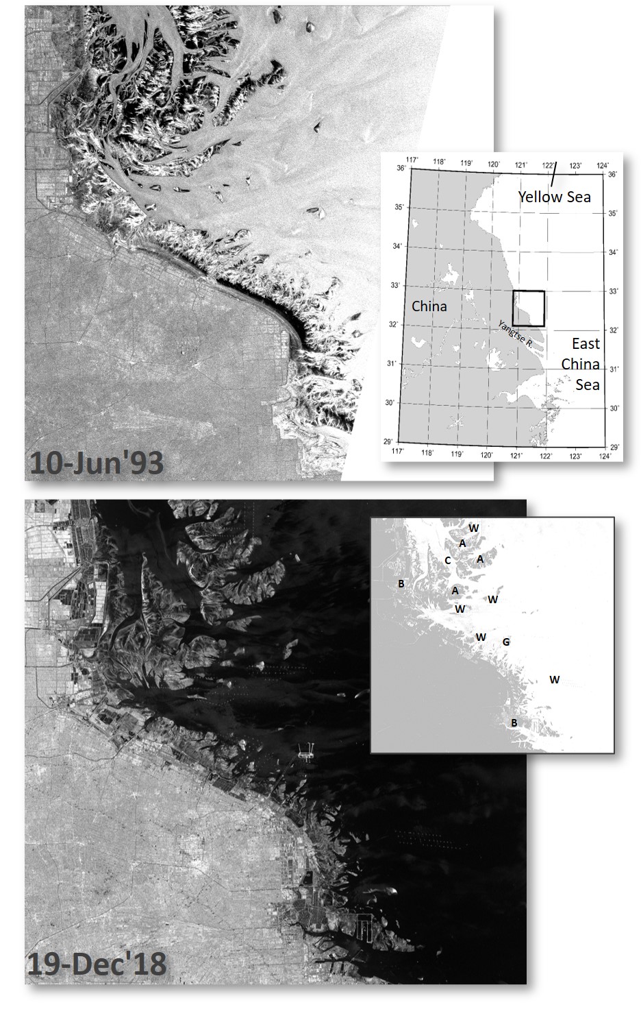
Exposed intertidal flats along the coast can be seen on both SAR images shown below, along with an extended system of sandbanks and mudflats in the images’ upper (northern) part, sometimes referred to as ‘Xinchuan Gang Shoals’. It is obvious that the wind speed was higher during the first image acquisition, resulting in a stronger radar backscatter from the sea (higher image brightness with respect to the mean image brightness of the mainland). This stronger wind may also be responsible for the distinct textures on the open sandbanks, i.e. the strong variation between dark and bright areas on the exposed flats, likely corresponding to higher and lower sediment moisture, respectively.
The intertidal flats along the coast, in the lower part of both SAR images, underwent only smaller changes during those 25 years between the image acquisitions, and only minor differences can be seen at some places. Major changes, however, can be found in areas of strong coastal developments, which are marked by two letters ‘B’ in the lower small map. Here, extensive land reclamation has resulted in changes of the coastline and therefore, of the overall topography in the intertidal range. The letter ‘G’ in the panel’s center marks the Rudong offshore LNG (liquefied natural gas) terminal that was built in the late 2000s (operational since 2011). The terminal is clearly visible as a bright construction in the center of the Sentinel-1A SAR-C image (lower panel).

Two SAR images (105 km × 102 km) of exposed intertidal flats on the Chinese coast (see map). Upper: ERS-1 SAR image, 10 June 1993; lower: Sentinel-1A SAR-C image, 19 December 2018. Letters in the middle right panel mark sites of interest: ‘A’: aquaculture; ‘B’: land reclamation; ‘C’: major tidal channel; ‘G’: gas terminal; ‘W’: windfarms. SAR images © ESA 1993, 2018.
The next figure shows (25 km × 25 km) details of four SAR images acquired in June 1993 and April 2000 (upper row; ERS-1), and in May 2009 and March 2017 (lower row; EnviSat and Sintinel-A, respectively) that demonstrate these changes in greater detail. It is obvious that the morphological changes in that area between 1993 and 2000 (upper two panels) were smaller than thereafter. The major tidal channel (marked ‘C’ in the small map above) appears in the upper left corner of the EnviSat ASAR image acquired in 2009, and it had extended towards south by the time of the Sentinel-1A SAR-C acquisition in 2017. This development occurred along with a general shift of the intertidal flats towards south-east, resulting in more exposed flats in the depicted area in 2017. Further brightness variations in the EnviSat ASAR image (lower left panel) are due to underwater sandbanks. Similar brightness variations can also be seen in the first ERS-1 SAR image (upper left panel), but are less pronounced, likely because of the higher wind speed at that time.

Morphological changes and aquaculture on extended intertidal flats off Rudong County. Details (25 km × 25 km) of two ERS-1 SAR (upper row), an EnviSat ASAR and a Sentinel-1A SAR-C (lower row) images acquired between 1993 and 2017 show that major changes occurred in recent years. The lower right panel depicts the location inside the SAR images shown in Figure 7.4. © ESA 1993, 2000, 2009, 2017.
Also note that the exposed flats appear more homogeneous on the Sentinel-1A SAR-C image (lower right panel), with less variable radar backscattering (image brightness). Apparently the flats had become flatter and showed a more homogeneous sediment distribution. Strip-shaped patterns can be identified on most of them, indicating extensive aquaculture (mainly seaweed; letters ‘A’ in the map). The growing area of those strip-shaped patterns demonstrates the ongoing intensification of aquaculture in the study area.
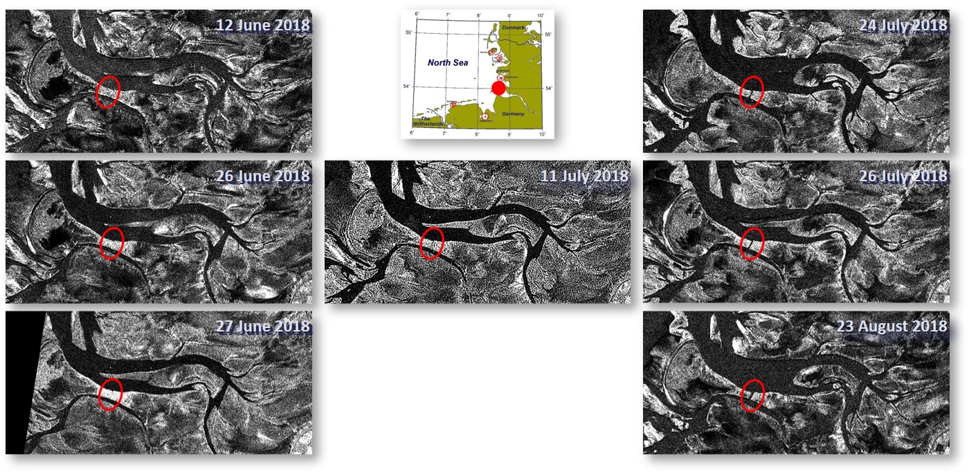
SAR sensors can also be used to identify shortterm changes in coastal environments, e.g. on intertidal flats. The next figure demonstrates this, using a series of Sentinel-1A/B SAR images (12.1 km x 5.6 km) of exposed intertidal flats on the German North Sea coast (see the map). A narrow flat, marked by the red ellipses, used to connect the small island of Trischen with the mainland, but has been cut by a new tidal channel that first appeared in July 2018 (middle panel). Within a few weeks, this tidal channel grew in width, under the action of strong local tidal currents.

Series of Sentinel-1A/B SAR-C image details of the same spot on the German North Sea coast (small map). Marked by red ellipses is a narrow sand flat that was cut by a newly developing tidal channel. © ESA 2018.
Space for Shore
In the frame of the Earth Observation Envelope Program (EOEP-5), The European Space Agency (ESA) decided to target the Coastal Erosion issue by funding a 2-yr project (2019/2020) that focuses on the prototyping of coastal erosion products derived from past and current Earth Observation missions, including the Copernicus Sentinel-1/2 which offer bi-weekly revisits all over Europe. The project 'Space for Shore' is end-user driven, with coastal managers defining required products, sharing their ground truth datasets from current monitoring programs, and finally testing the new products, providing feedback about their relevance.
The project's philosophy is based on mutual cooperation between SAR and optical remote sensing specialists, who jointly identify relevant coastal erosion indicators, as required by European coastal managers, for all European coastline types and patterns of coastal erosion. The Space for Shore consortium has currently five national contact points in each of the participating countries (Germany, France, Portugal, Romania and Greece), enabling proximity with local and national authorities. This network is expected to grow in the coming years. To learn more about the project visit its website.
Theses, Publications
- Peters, S., 2022: Bestimmung morphodynamischer Veränderungen an der deutschen Nordseeküste mithilfe von Synthetik Apertur Radar Daten, Bachelor thesis, Universität Hamburg, Fachbereich Geowissenschaften, 26 pp.
- Gade, M., 2020: SAR Monitoring of Coastal Changes in Intertidal Areas. Proceed. Intern. Geosci. Remote Sens. Sympos. (IGARSS) 2020, virtual, 27 September - 2 October 2020.
- Gade, M., 2020: Monitoring of Intertidal Areas and Coastal Habitats. In Marine Survellance With SAR Data, Di Martino, G., Iodice, A. (Eds.), IET Publishing, 327pp, ISBN 978-1-78561-601-3.
- Gade, M., and S. Melchionna, 2016: Joint Use of Multiple Synthetic Aperture Radar Imagery for the Detection of Bivalve Beds and Morphological Changes on Intertidal Flats, Estuar. Coast. Shelf Sci., 171, 1-10, doi:10.1016/j.ecss.2016.01.025
Results

 .. back to the KFEW3O ...